New developments in 2015
Since this page was originally written in 2011 to give a general overview of the issues on which the Friends would work and campaign, some of the original objectives have seen a marked progress, and some new ones have arisen.
The reader's attention is drawn to two new issues which have arisen in the summer of 2015 and for which there is further information on other pages.
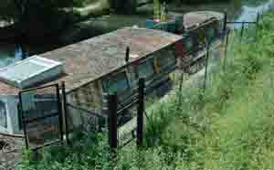
Railway depot to be set alongside canal
News headers : news item : full article download
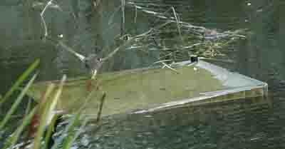
Slough Arm to be used for winter moorings in 2015-16
Towpath conditions
When the towpath was re-opened it provided at least one meter width of even surface adequate for walking, running, riding or pushchair along most of the length of the arm. In places natural growth has narrowed the available space and the surface is now uneven and drains badly making it difficult to pass in poor weather. To make a safe and friendly route it should be possible to walk or ride side by side in order to facilitate conversation or supervise youngsters, and the surface should be easy to traverse in all weathers. Compare this with the fine gravel surface used on the Jubilee River which is part of the National Cycle Network.
In January 2011 a survey of the towpath was done to support a new campaign. You can see a composite of the pictures here. Anyone needing one can request a higher quality version
Resurfacing work took place in March 2012. Click here for further information

In 2009 a project is in hand to use volunteer effort to trim back the plant growth over the path, and to remove the ground growth revealing the full width of the original path.
Moorings
Boats visiting Slough currently have nowhere to tie up for a short stay. Along most of the length of the arm banks are rough and tree and reed growth make it difficult to board. In addition security is also a concern with boats moored at the basin suffering loss and damage in recent years. Across the UK waterway network secure gated moorings is the desired solution, consisting at its simplest of a section of suitable bank fenced off to make boats moored on this section inaccessible by land. The moorings are accessed by a lockable gate set into the fence which is opened with a standard British Waterways key to which licence holding boaters will have access. Residential moorings may provide water, power & sewerage services in addition to security fence.
As a first step the Friends would like to see the provision of simple visitor moorings within a mile or so of the basin.
Bank and water cleaning
Basin development
Slough Basin as it stands at the moment is hardly a place one would want to visit twice either by boat or on land. British Waterways and Slough Borough Council control land around the water and there is potential to develop this into a smart, safe public open space which would be a credit to the area and an example of upgrading a tired and forgotten space into something contemporary and relevant.
Thames link
A link between the Slough arm and the non tidal Thames has been on British Waterways’ wishlist for many years. The benefits for boat navigation are clear from this map, sketched by Mike Timms. Less obvious is the potential benefit to land based users. Depending on the route adopted, a new safe ‘off road’ cycle and walking route might be opened which would link Slough to the industrial areas surrounding Heathrow. The original survey route favoured a route branching off some way short of the basin, and the excavation of a tunnel, but revisiting this more recently has introduced the possibility of extending from the basin. The construction of the Jubilee River further alters consideration of the route, entering the lower end of the Jubilee river shortening the length of new waterway required and perhaps allows an easier crossing of the M4. In the last two years the Friends have tried to push this project up the national waterways agenda and recently have brought together key personnel in British Waterways and Slough Borough Council resulting in meaningful discussions, and at the end of 2008 a visit to see the latest Waterways project nearing completion in Liverpool involving extension of the existing Leeds & Liverpool canal into the docks alongside the Mersey, and the use of new canalway to create a major feature in a public space. See visits page and BW site. In 2009 the Thames Link project was included in Slough Borough Council's local development framework, but partly because there is no fixed route for the link there is an ongoing danger of it being removed from the framework and falling off the immediate agenda.
