Both the waterway and the towpath were closed earlier in the year at bridge 2a where there had been a serious structural failure of the bridge.
From 25/7/13 it's open again! See the story below
As of Thursday 25th July 2013 both the canal and the towpath have been reopened
Bridge 2 consists of a pipe gantry and a footbridge a short distance east of the M25 roadbridge, which has no connection to the towpath. The nearest points to get on or off the towpath are bridge 3 Thorney Lane to the west, and bridge 1 to the east which carries a footpath into Little Britain.
INTERIM UPDATE 8/5/13 see below.
INTERIM UPDATE 4/6/13 see below
INTERIM UPDATE 24/6/13 see below
INTERIM UPDATE 29/06/2013 see below
NEARLY FINAL UPDATE 1/7/2013 see below
ANOTHER NEARLY FINAL UPDATE 6/7/2013 see below
FINAL UPDATE 25/7/2013 see bottom of page

This crack is in the support pier on the southern bank.
It appears that there has been some slippage towards the canal of about eighteen inches in places
Expected duration of closure
At the time CRT first contacted the Friends their expectation was that this closure might have to remain in place for the first two weeks of May while remedial work was done to make the area safe.
We will post any news we are given here. The CRT's web pages may be updated more quickly.

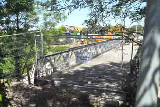
This is the view when approaching from the west side. As of 29/4/2013 the waterway is closed by a boat hull tied on the east side, and fencing blocks the path on both sides of the failing bridge. This was taken on Monday morning, at which time the deck of the bridge had not collapsed.
The pictures of failed brickwork refer to the far structure. The gantry in foreground carries pipes only with no walkway, and this appears to be intact.

This is the eastern face of the southern bridge pier.
This is the western face of the southern pier showing part of the brick structure displaced.


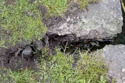
The ground movement under the bridge pier is reflected in damage to the canal bank.
Cracks have appeared in the ground at the towpath edge.
This is another crack at the edge of the towpath
The Friends have produced a poster to warn users of the towpath that there is a closure further along and minimise the inconvenience of being unable to complete their intended journey. A map shows the exact location of the closure. We have put these posters at several access points from Slough Basin towards the obstruction.
There is a link here to a pdf document which includes a map showing the location of the closure. Please feel free to print it for yourself or issue it to anyone who needs to know. The CRT have also produced a map showing diversionary routes around the obstruction for walkers and cyclists, following some feedback they have issued version 2. I haven't managed to find it available on their web pages, but they have sent it to us, so it is available for download here.
UPDATE 8/5/2013

I visited the site by bike on the afternoon of 7/5/13 from the west side. The barriers on the towpath have been moved back, making it harder to get a look at developments, or to take photos of progress. The photo I did take shows a large pile of gravel or similar having been tipped into the canal from the north bank.
We understand that the plan is now to fill the canal with a gravel barrier under the bridge, which will prevent further movement of the southern bank and towpath, and provide a solid base for machinery to come and work under the bridge structure. Once all services which had been carried over the original bridge have been rerouted the old bridge will be taken down.
Present expectation is that the closure is now likely to last at least six weeks.
UPDATE 4/6/2013
I made another visit to the site today, approaching on the towpath from the west side. The towpath barrier has now been boarded preventing any observation, retreating back to the fishing platforms I could see work ongoing and some machinery on the gravel barrier.

I left the towpath and worked my way round to the footpath that crosses the failed bridge, from which I could observe the works from above.

Heavy plant is in use or parked on the north bank, I couldn't be certain but the bridge deck and railings may be new structures, or at least repaired.
FInally returning to the towpath I approached the works from the east. Again boarding has been put up on the barrier so I retreated to a place where a kink in the towpath gave a better view.

Now we get a picture of the scale of work the contractors have undertaken. In the foreground the boat hull blocking the canal, and barrier blocking the towpath. Immediately above in the picture the banked up gravel which is plugging the watercourse preventing the bank collapsing further and providing a platform to work from.

Here is a closer view, at bottom the gravel plug on which a man and some heavy duty support structures are standing, and to the left part of the original bridge supports with a slightly wider crack in it. The first structure seen above is the pipe bridge which is set back beyond the footbridge.
The Friends have heard nothing through official channels and today I didn't get chance to speak to anyone working at the site, but somewhere on the rumour vine there is talk of the works being completed around the middle of June, and the canal and towpath both reopening. It will be around this time that the work on Trenches railway bridge is completed and the walking and cycling route to the south of Trenches bridge reopens.
** While in the process of writing this update we have heard through Waterscape that the reopening of the canal has been delayed by one week because of the difficulty in removing the bridge deck. This implies that the bridge deck I thought looked good today is in fact the original. The Friends were not aware of any prior reopening date having been published**
UPDATE 24/6/2013
This update is based on a visit to the site on Saturday 22/6, and information received from CRT today. There was some expectation that the work would be finished enough to reopen the canal today. The visit, and my enquiry were to see if there would indeed be an opening worth coming to see.

From the apparent state of the site there is some way to go. Obvious progress is that the bridge deck has now been rolled back onto the north bank, and the support structures enabling this to happen have been removed. What is not obvious just outside the bottom left of the photo above, is that the southern support pier which suffered the failure appears to have been completely removed. Appearances suggest that work had moved to the next stage of securing the south bank and towpath ground.
Today CRT have told me that while putting in the piles which will reinforce the towpath edge, probably those in the foreground here, the machinery hit concrete below the ground and has sustained some damage, bringing work to a halt and causing a further delay.
They have therefore suggested a revised opening date of Saturday 29th June. I am hoping for confirmation of this on Friday afternoon.
UPDATE 29/6/2013
The CRT announced on Friday 28 June that reopening on Saturday 29th would not be achievable, and that they hoped to open the canal on Monday 1st July.
Visiting the site on the morning of Saturday 29th some progress was evident, with workers completing the piling along the southern bank which will presumably form the new edge with the towpath.
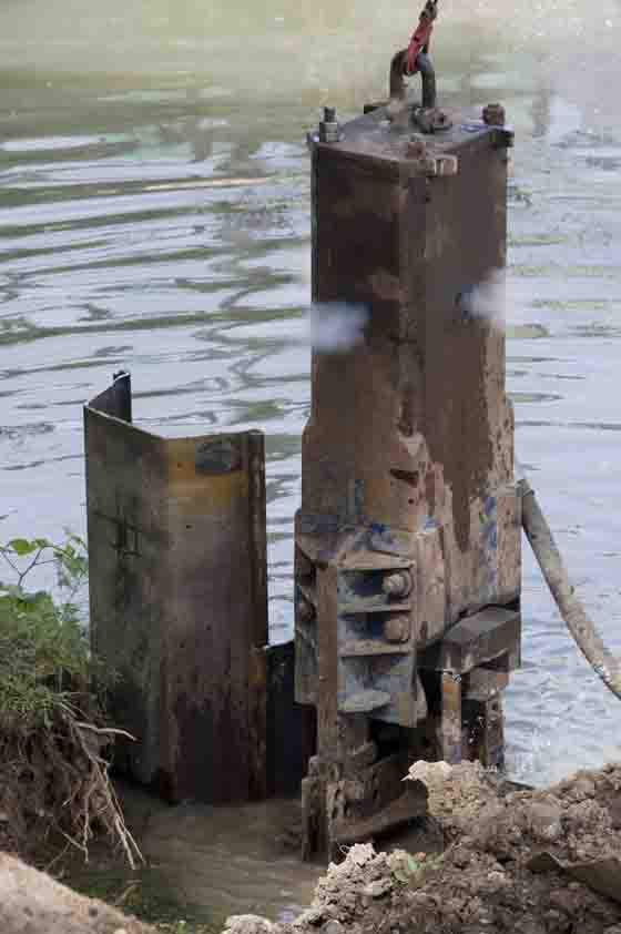
The wider view was similar to that seen on 24/6, with the difference that the red digger and an air compressor were down on the gravel barrier at canal level driving a pile hammer which was completing the towpath edge seen in foreground, and another worker was cutting the surplus from the tops of the piles with an angle grinder.

The latest images show the hammer driving in the piles which form the new towpath/canal edge, and the completed work after trimming the surplus metal. I am expecting the space behind the metalwork currently filled with water to be filled in with earth to form the new towpath.
We are now hoping for re-opening on Monday.
UPDATE 01/07/2013
I cycled to Reeds Bridge this morning expecting to photograph the finished work and intending to put signs at the towpath joining points on my return announcing that the work was finished and both path and waterway opened. Sadly I came up against the same barrier across the towpath by the M25 roadbridge. The canalway is open but the towpath is not.
I made my way to the high vantage point from which I could see that the towpath is not really a towpath. The earth slope in the foreground of the photo below slopes most of the way to the new piling at the water's edge. This is work yet to be completed. While I was there the digger started up and was doing something on the north bank.
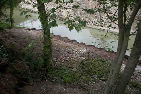
I contacted the CRT to ask what was happening, unfortunately today I didn't have time to stay while I waited for an answer, and came home. The view below is from the east side and shows the profile of the earth slope and the need for more work to reconstruct a towpath.
On the left is the boarding blocking the towpath, immediately behind it is the earth slope which is where the southern bridge pillar once stood. The narrowest point in the watercourse with the remainder of the gravel mound on the right bank shows where the other bridge support would have been. I do not think the big excavator could get close to the water edge on the right side, or reach across to work on the towpath, so this may have to be done with other equipment based on the southern bank.

After reaching home I did get a further message from the CRT who by that time had managed to contact the people working on the site. They expect the towpath to be completed and open this Wednesday afternoon.
When this is confirmed I will post the news here
! Thurs 4/7/13 The towpath didn't open, awaiting new information !
UPDATE 06/07/2013
I cycled to Reeds Bridge on the morning of Thursday 4/7 expecting to find the towpath open. It wasn't. There were workmen on the towpath side of the canal, who I was just about able to shout to from the high vantage point nearby, and hear their replies.
The appearance of the towpath side hadn't changed much from my last visit, perhaps a little earth had been removed from the slope but the surface appeared to be nothing like complete. I'm not putting up more photos, there wasn't enough visible change.
On Saturday afternoon 6/7/13 I have received a message from CRT saying that the towpath will remain closed until the end of July as there are further issues with the waterway wall and with cables associated with the towpath.
The Friends will put up signs at the basin confirming that the towpath is still not open all the way to the junction in the next couple of days.
UPDATE 25/07/2013
The CRT told me on the 24th July that the towpath had reopened. I confirmed that this morning and have posted photos of the repaired path below.
An ongoing warning remains in place that it will have to close temporarily again on occasions in the future to resolve outstanding problems with cables which used to run under the towpath, and for the replacement of the bridge deck carrying the footpath.
If we received advanced notice of these future works I will post them here.
I have put posters at most of the road access points to the towpath today informing towpath users that the entire towpath can be travelled again. As the entire length of the towpath was covered in one go there seems no point in asking people to download and distribute the poster so it is not on the server.

Above is the view of the repaired towpath looking to the east. Out of view to the left the removed decking can still be seen on the high ground to the north. The repaired towpath is not wide but the surface is adequate for walking and cycling.

This view is taken facing west and shows the pipe bridge which remains after the footpath deck has been removed. It also gives a close up view of the new towpath surface and of the interlocking piles which reinforce the water edge.